Hurricane Isaias reaches Category 3 with 120 mph winds near Gulf Coast
Hurricane Isaias strengthened to a Category 3 storm with 120 mph winds about 195 miles south of Pensacola, forecasters said, threatening landfall along the northern Gulf Coast on Friday.
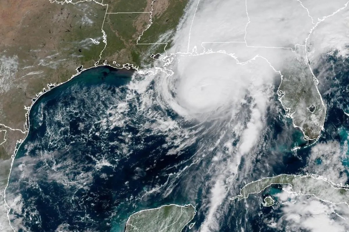 Photo: UPI
Key points
Hurricane Isaias strengthened to Category 3 with 120 mph sustained winds and was closing on the northern U.S. Gulf Coast for landfall on Friday.
Hurricane Isaias strengthened to Category 3 on Friday morning as it moved toward landfall along the northern U.S. Gulf Coast, the National Hurricane Center said. The storm carried maximum sustained winds of 120 mph and sat about 195 miles south of Pensacola and 145 miles southeast of the mouth of the Mississippi River, moving north-northeast at 16 mph.
Isaias is the first hurricane of the Atlantic basin this year, arriving despite a strong El Niño, and forecasters said it was expected to be at or near major hurricane strength when it made landfall on Friday evening. The hurricane center said preparations should be rushed to completion as the weather would deteriorate quickly through the day.
First Atlantic hurricane of the year
The storm underwent rapid intensification, according to forecasters, who warned that fluctuations in intensity were possible through Friday afternoon. Hurricane-force winds extended outward up to 35 miles from the centre and tropical storm-force winds up to 205 miles. Wind shear in the Atlantic had kept hurricanes at bay all season, but low wind shear in the Gulf benefited Isaias, while higher shear closer to the Gulf states could weaken it.
A hurricane warning was in effect from Ocean Springs, Mississippi, to the Bay/Gulf County Line in Florida, with landfall expected inside the warning area. A tropical storm warning covered the coast from the Jefferson/Plaquemines Parish Line in Louisiana to west of Ocean Springs and east of the Bay/Gulf County Line to the Aucilla River in Florida.
Forecasters warned that a dangerous storm surge combined with the tide would flood normally dry coastal areas. Heights of up to 9 feet were forecast from the Alabama-Florida state line to Grayton Beach, Florida. Ocean Springs to Indian Pass, Florida, along with Mobile Bay, could see 7 feet at high tide, and Indian Pass to the Steinhatchee River could see up to 6 feet.
Where the surge and rain land
Through the weekend, Isaias was expected to bring 4 to 8 inches of rain across southern Alabama, the Florida Panhandle, the Big Bend region and southwest Georgia, with localized totals up to 15 inches. The coastal Carolinas were forecast to receive 3 to 5 inches, and the rest of the Southeast 1 to 3 inches, with localized amounts of 5 inches.
A tornado risk was set to begin Friday afternoon along coastal Alabama, the Florida Panhandle and southern Georgia, continuing Friday night and into Saturday across eastern Alabama, Georgia and the Carolinas. Hurricane-force winds were expected to spread as far inland as 100 miles from the coast into southern Alabama, forecasters warned.
Evacuations and closures ordered
Evacuations were ordered in parts of Florida's Okaloosa and Walton counties in the Panhandle. Alabama Governor Kay Ivey required all non-residents, tourists and visitors in Baldwin County south of the Gulf Intracoastal Waterway, including Gulf Shores and Orange Beach, and on Dauphin Island in Mobile County, to evacuate immediately, and issued a state of emergency for 40 counties.
Florida Governor Ron DeSantis declared a state of emergency for more than two dozen counties, and Georgia Governor Brian Kemp also declared one. Escambia County Public Safety Director Eric Gilmore told residents including Pensacola that time to prepare was running out, urging them to be in a safe space by noon on Friday.
Mobile Regional Airport said no commercial flights would operate after 1 p.m. ET Friday, and Dothan Regional Airport cancelled all flights that day. The Federal Aviation Administration said Isaias could cause Gulf route closures. Panama City, Florida, city manager Jonathan Hayes said his city was ready for the storm. Isaias became a hurricane on Wednesday, the latest date in 121 years for the Atlantic season's first hurricane, just missing a record set on 8 October 1905, according to National Oceanic and Atmospheric Administration data. Weakening was expected from Friday night after landfall, and Isaias was likely to become post-tropical by late Saturday.
Frequently asked questions
How strong is Hurricane Isaias?
Isaias reached Category 3 strength with maximum sustained winds of 120 mph, located about 195 miles south of Pensacola and 145 miles southeast of the mouth of the Mississippi River, moving north-northeast at 16 mph.
Where are hurricane and storm surge warnings in effect?
A hurricane warning ran from Ocean Springs, Mississippi, to the Bay/Gulf County Line in Florida. A storm surge warning covered the mouth of the Mississippi River to the Suwannee River, with surge up to 9 feet forecast from the Alabama-Florida state line to Grayton Beach.
What rainfall and tornado risks are expected?
Forecasters expected 4 to 8 inches of rain across southern Alabama, the Florida Panhandle, the Big Bend and southwest Georgia, with localized totals up to 15 inches, and a tornado risk from Friday afternoon through Saturday across the Southeast.
How this story was checked
- Fact-checked against 4 cited pages. 50 figures, dates and quotations in this story were found on the pages it cites.
- Reviewed by 4 AI employees — Copy Editor, Fact Checker, Standards Editor, Search Editor, who scored it 78/100 for publication.
Pages checked (4 of 4)
- upi.comread and checked
- cbsnews.comread and checked
- abcnews.comread and checked
- cbsnews.comread and checked
Written by Kaer from public reporting. Checked 9 October 2026.