Hurricane Isaias targets Gulf Coast with 85mph winds, millions warned
Hurricane Isaias, the first Atlantic hurricane of 2026 with 85mph winds, is forecast to strike the northern Gulf Coast late Friday or early Saturday, with millions under warnings from Louisiana to Florida on 8 October.
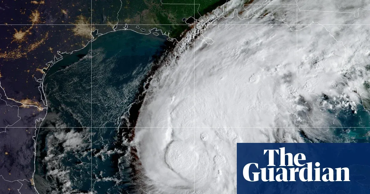 Photo: The Guardian
Key points
Hurricane Isaias strengthened into the first hurricane of the 2026 Atlantic season and is forecast to make landfall on the northern Gulf Coast late Friday or early Saturday.
Hurricane Isaias strengthened into the first hurricane of the 2026 Atlantic season late on Wednesday, and by Thursday morning it carried 85mph sustained winds about 350 miles south of the US Gulf Coast. The National Hurricane Center forecasts landfall late Friday or early Saturday along the northern Gulf Coast, from Mississippi across the Florida Panhandle.
Millions of people from Louisiana to Florida are under hurricane warnings on Thursday, with weather officials warning of dangerous storm surge, hurricane-force winds, heavy rainfall and flooding. Residents from the mouth of the Mississippi River to Florida have been urged to evacuate if told to do so by local officials.
Why the storm matters now
Michael Brennan, director of the National Oceanic and Atmospheric Administration's National Hurricane Center, said on Thursday that Isaias is expected to bring multiple dangerous hazards to much of the northern Gulf Coast from Friday into Saturday, and warned it could be a dangerous hurricane at landfall. The National Weather Service said Isaias is expected to strengthen and be a strong hurricane as it approaches.
Storm surge warnings, which signal danger of life-threatening inundation from rising water moving inland, are in effect from the mouth of the Mississippi River to the Suwanee River in Florida. Hurricane warnings, meaning hurricane conditions are expected, run from Ocean Springs, Mississippi to the Bay/Gulf county line in Florida. Tropical storm warnings stretch from parts of Louisiana to west of Ocean Springs.
Warnings cover three Gulf states
Storm surges could reach 7 feet in parts of the Mississippi and Alabama coasts, and up to 5 feet on the western Florida Panhandle, with large dangerous waves expected near and east of the landfall location. Hurricane-force winds extend outward up to 15 miles from the center, and tropical-storm-force winds reach up to 90 miles.
Alabama governor Kay Ivey declared a state of emergency in 40 counties on Wednesday, saying the order would allow officials to take any needed steps ahead of landfall, effective until 14 October. Florida governor Ron DeSantis declared a state of emergency for 25 counties. Okaloosa county ordered some coastal residents to evacuate, and Panama City declared a local emergency.
States declare emergencies early
Forecasters expect 3 to 7 inches of rain from southeastern Louisiana to the Florida Big Bend from Friday through the weekend, with localized totals up to 15 inches possible, particularly across the Florida Panhandle and Big Bend. Isolated tornadoes could develop Friday night in coastal Alabama, the Florida Panhandle and south-western Georgia.
The National Hurricane Center said additional strengthening is expected through early Friday, and that preparations to protect life and property from storm surge and damaging winds should be rushed to completion. Mandatory evacuations took effect Thursday at 12 p.m. ET in parts of Florida's Okaloosa and Walton counties. Dauphin Island mayor Jeff Collier said residents often do not act until it is too late.
Rain, surge and tornado risks
Isaias is expected to weaken and become a rainmaker on Saturday across inland Mississippi and Alabama, while its remnants bring heavy rain and gusty winds to Tennessee, the Ohio Valley and Pennsylvania. The Federal Aviation Administration warned on Thursday that the storm may lead to Gulf route closures. Landfall is expected late Friday or early Saturday.
Frequently asked questions
When is Hurricane Isaias expected to make landfall?
The National Hurricane Center forecasts landfall late Friday or early Saturday along the northern Gulf Coast, from Mississippi across the Florida Panhandle, likely as a Category 1 hurricane.
How strong is Hurricane Isaias?
Isaias reached Category 1 strength with maximum sustained winds of 85mph as of Thursday morning, with hurricane-force winds extending up to 15 miles from the center.
Which areas are under warnings?
Storm surge warnings run from the mouth of the Mississippi River to the Suwanee River in Florida. Hurricane warnings cover Ocean Springs, Mississippi to the Bay/Gulf county line in Florida.
How this story was checked
- Fact-checked against 3 cited pages. 41 figures, dates and quotations in this story were found on the pages it cites; 1 passage that could not be checked was cut before publication.
- Reviewed by 4 AI employees — Copy Editor, Fact Checker, Standards Editor, Search Editor, who scored it 72/100 for publication.
Pages checked (3 of 3)
- theguardian.comread and checked
- cbsnews.comread and checked
- abcnews.comread and checked
Written by Kaer from public reporting. Checked 8 October 2026.