Hurricane Simon weakens to Category 1 off Mexico coast
Hurricane Simon weakened to Category 1 off Mexico's Pacific coast with 150 kph winds on 13 October 2026, after passing as a category 4 storm with 250 kph winds on 11 October.
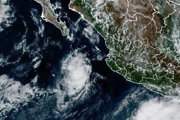 Photo: UPI
Key points
Hurricane Simon weakened to Category 1 off Mexico's Pacific coast with 150 kph sustained winds, down from category 4 strength with 250 kph winds two days earlier.
Hurricane Simon weakened to Category 1 off Mexico's Pacific coast on 13 October 2026, with maximum sustained winds of 150 kilometers per hour (93 miles per hour) and gusts reaching 185 kph, the National Civil Protection Coordination reported. The storm's center sat west of Cabo Corrientes in Jalisco and south-southwest of Mazatlan in Sinaloa.
The downgrade matters because Simon had passed close to the Mexican coast as a category 4 storm just two days earlier, on 11 October 2026, with sustained winds reaching 250 kilometers (155 miles) per hour. Even at Category 1, authorities warned that heavy rainfall, strong winds and dangerous waves would continue along western Mexico, since a hurricane losing intensity can still deliver destructive water and surf.
From category 4 to category 1
The National Hurricane Center said Simon weakened back to a Category 1 hurricane on Wednesday as it drifted southwestward of Mexico, and discontinued all hurricane watches and warnings. The storm had regained Category 2 strength late Tuesday before dropping again. It was located about 165 miles west-southwest of Cabo Corrientes and 250 miles south-southeast of Cabo San Lucas in the center's 8 a.m. MST update.
Simon's maximum sustained winds stood at 90 mph, down 20 mph over the previous 12 hours, and it was moving southwest at a 2 mph crawl after being essentially stationary through Tuesday. The National Hurricane Center said the hurricane was likely to move slowly and erratically during the next day or two, with a turn toward the north or north-northwest forecast by Friday.
The Sierra Madre mountains along the coast appear to have sapped some of Simon's strength. The National Hurricane Center noted that the topography tempered the storm's intensity somewhat and shrank the size of its wind field as the inner core brushed the coast on 11 October 2026. Hurricane-force winds still extended outward up to 10 miles from the center, with tropical-storm-force winds reaching 35 miles.
What the mountains did to the storm
Despite the smaller wind field, the major hurricane delivered heavy rain and flooding to coastal areas, including the port city of Manzanillo, and raised the risk of mudslides in mountainous areas. Simon's eye was about 50 kilometers (30 miles) offshore, between Manzanillo and Puerto Vallarta, when the Suomi NPP satellite imaged it around 2:30 p.m. local time on 11 October 2026.
The National Meteorological Service forecast heavy to very heavy rainfall across Jalisco, Nayarit, Colima and Sinaloa, raising concerns about flooding and landslides. Jalisco and neighbouring Colima could face hazardous coastal conditions, while Nayarit could be affected by the storm's rain bands and Sinaloa remained under close monitoring as Simon tracked northwestward. Residents were advised to follow guidance from civil protection officials.
Where the rain will fall next
Forecasts of Simon's intensity and path remained "very low confidence" on the morning of 13 October 2026, as the storm's evolution continued to defy meteorologists' expectations. The system may steer north and enter the Gulf of California before making landfall, and large swells causing dangerous nearshore conditions were expected along portions of the southwestern and west-central coasts of Mexico in the coming days.
The National Hurricane Center forecast some intensity fluctuations through Thursday night, followed by weakening on Friday and into the weekend. Simon is a very small hurricane, the center said, which helps explain why its wind field responded so quickly to the coastal mountains and to changes in the surrounding atmosphere over the Pacific.
In the early morning hours of 11 October 2026, satellites captured Simon's effects reaching the upper atmosphere. The VIIRS day-night band on the NOAA-21 satellite showed atmospheric gravity waves radiating from the hurricane, ripples formed when latent heat released near the eyewall drives strong convection, building tall cumulonimbus clouds whose updrafts send waves into the stratosphere and mesosphere.
Those waves are not always observable, because upper-atmosphere winds can dissipate them before they reach the mesosphere, where they appear as ripples in airglow, the faint light emitted by gases at high altitudes. On that night, minimal illumination from the Moon helped the airglow stand out against the instrument's sensitivity to reflected moonlight.
Authorities continue to track the hurricane as it moves over the Pacific, with its future path and the extent of its effects depending on changes in its intensity and movement. The National Hurricane Center's forecast of a turn toward the north or north-northwest by Friday, and weakening into the weekend, sets the next checkpoint for Mexico's western states.
Frequently asked questions
How strong is Hurricane Simon now?
Hurricane Simon weakened to Category 1 off Mexico's Pacific coast on 13 October 2026, with maximum sustained winds of 150 kilometers per hour (93 miles per hour) and gusts reaching 185 kph, according to the National Civil Protection Coordination.
How strong was Hurricane Simon at its peak near Mexico?
Simon passed close to the Mexican coast as a category 4 storm on 11 October 2026, with sustained winds reaching 250 kilometers (155 miles) per hour as it crept north-northwest, with its eye about 50 kilometers offshore between Manzanillo and Puerto Vallarta.
Which parts of Mexico are at risk from Hurricane Simon?
The National Meteorological Service forecast heavy to very heavy rainfall in Jalisco, Nayarit, Colima and Sinaloa, raising concerns about flooding and landslides, with hazardous coastal conditions possible in Jalisco and Colima and dangerous nearshore swells along southwestern and west-central Mexican coasts.