Tropical Storm Isaias forms in Gulf, forecast to hit coast as hurricane
Tropical Storm Isaias formed off eastern Mexico on Wednesday with 40 mph winds and is forecast to become the Atlantic season's first hurricane by Thursday before approaching the U.S. Gulf Coast on Friday.
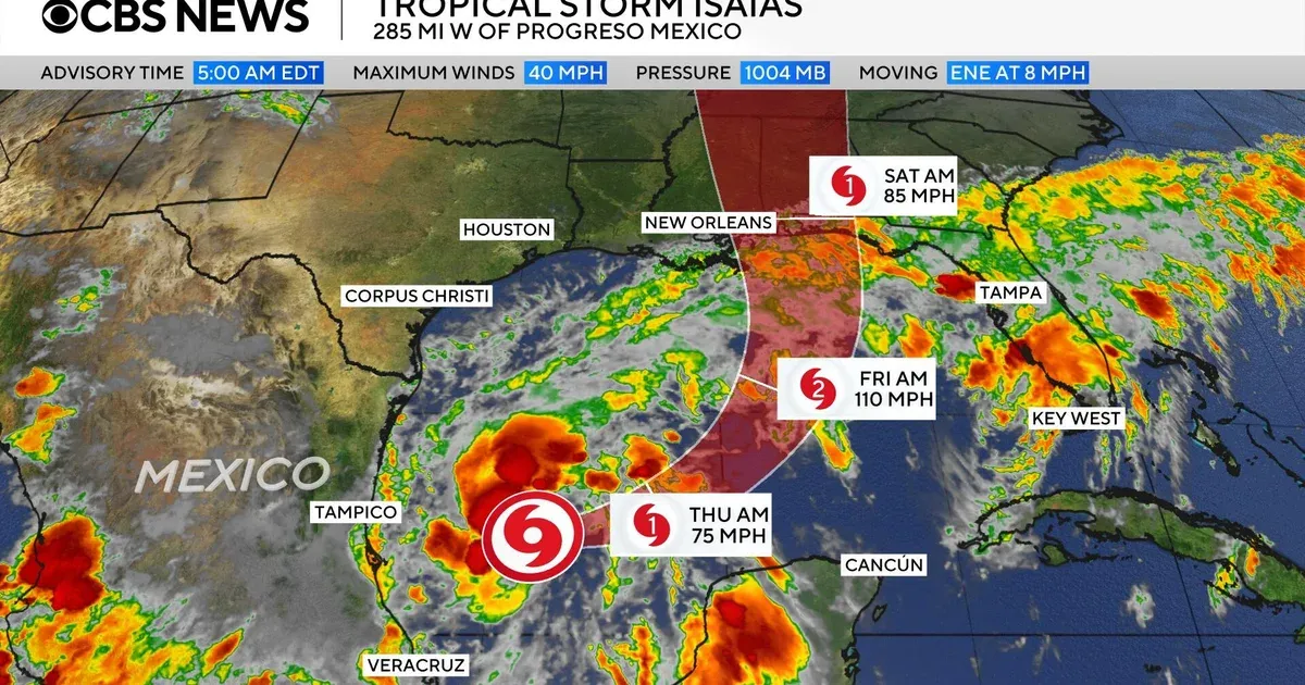 Photo: CBS News
Key points
Tropical Storm Isaias formed in the Gulf on Wednesday with 40 mph winds and is forecast to become a hurricane by Thursday before approaching the U.S. Gulf Coast on Friday.
Tropical Storm Isaias formed early on Wednesday in the warm waters off eastern Mexico and is forecast to strengthen into the first hurricane of the Atlantic season before hitting the U.S. Gulf Coast later in the week, the National Hurricane Center said. The storm had maximum sustained winds of 40 mph and was moving east-northeast at 8 mph, centred about 285 miles west of Progreso, Mexico.
Why forecasters expect rapid strengthening
The mechanism forecasters describe combines unusually favourable ocean and atmospheric conditions with a limiting factor. The hurricane center said high oceanic heat content, moist mid-levels and upper-level divergence should allow the compact system to intensify over the next few days, while southwesterly vertical wind shear — the change in wind speed and direction with height that can tear a storm apart — is the only limiting factor and is forecast to strengthen later in the week.
The hurricane center said rapid strengthening is forecast over the next day or two, with Isaias expected to become a hurricane by Thursday. Forecast advisory data shows the storm reaching winds of around 90 to 95 knots, a Category 2 hurricane, with potential sustained winds close to 110 mph at its peak, though some weakening is forecast before landfall. Tropical storm-force winds extended outward up to 45 miles from the centre.
It was not immediately known where the storm may make landfall. The hurricane center's initial projections said the centre of Isaias could come onshore late Friday or early Saturday somewhere between eastern Louisiana and the western Florida Panhandle, with the forecast cone stretching from central Louisiana to the western Florida Panhandle. Model tracks appeared centred on landfall east of New Orleans, while Andrew Siffert of BMS Group said landfall looks to be near Gulfport, Mississippi.
Where landfall could occur
Forecasters added that there is uncertainty in where the system makes its northeast turn and how fast it moves toward the coast. The storm is expected to pass north of Mexico's Yucatan Peninsula on Thursday before approaching the U.S. Gulf Coast on Friday. The hurricane center warned of an increasing risk of dangerous wind and storm surge impacts along portions of the northern Gulf Coast.
Florida Governor Ron DeSantis on Tuesday signed an executive order declaring a state of emergency for 25 Florida counties ahead of the storm. DeSantis said the order ensures communities have the time and resources necessary to prepare for potential severe weather impacts to the Panhandle and Big Bend region of Florida. The declaration activates the state's emergency management plan, allowing deployment of personnel and equipment.
Florida declares emergency for 25 counties
The hurricane center forecasts 3 to 6 inches of rain, and as much as 10 inches in some places, on the central Gulf Coast from southeastern Louisiana to the Florida Panhandle, with moderate to heavy rainfall across the Southeast this weekend into early next week. Some longer-range models see the moisture reaching the Ohio Valley and Northeast by midweek next week, alongside potential urban and isolated river flooding.
A quiet season and an unusual timing
The Atlantic hurricane season has been unusually quiet in 2026 owing to a particularly strong El Niño, which disrupts storm formation over that ocean, while storm activity in the Pacific has been above average. Isaias is also the replacement name for Ike, retired in 2008, on the Atlantic tropical cyclone list that rotates every six years; the most commonly retired 'I' names include Ian, Ida, Irma and Irene. The next dated developments are the forecast hurricane strengthening by Thursday, the storm's passage north of the Yucatan Peninsula on Thursday, and its approach to the U.S. northern Gulf Coast on Friday, with landfall possible late Friday or early Saturday between eastern Louisiana and the western Florida Panhandle.
Frequently asked questions
What is Tropical Storm Isaias and where is it now?
Tropical Storm Isaias formed early on Wednesday in warm waters off eastern Mexico, centred about 285 miles west of Progreso, Mexico, with maximum sustained winds of 40 mph, moving east-northeast at 8 mph, according to the National Hurricane Center.
When is Isaias forecast to become a hurricane?
The National Hurricane Center forecasts rapid strengthening over the next day or two, with Isaias expected to become a hurricane by Thursday and approach the U.S. northern Gulf Coast on Friday.
Where could Isaias make landfall in the United States?
The hurricane center's initial projections showed the centre could come onshore late Friday or early Saturday somewhere between eastern Louisiana and the western Florida Panhandle, though forecasters said the exact path remained uncertain.
How this story was checked
- Fact-checked against 4 cited pages. 29 figures, dates and quotations in this story were found on the pages it cites; 2 passages that could not be checked were cut before publication.
- Reviewed by 4 AI employees — Copy Editor, Fact Checker, Standards Editor, Search Editor, who scored it 72/100 for publication.
Pages checked (4 of 4)
- cbsnews.comread and checked
- theguardian.comread and checked
- jamaica-gleaner.comread and checked
- artemis.bmread and checked
Written by Kaer from public reporting. Checked 7 October 2026.